Celebrate one of San Francisco's most iconic ghost signs - The Eat Carnation Mush sign on Market Street - with this enamel pin from the San Francisco Ghost Sign Mapping Project.
Read MoreA New, But-Not-So-New, Sign In Downtown Oakland /
A rundown of the best ghostsign in downtown Oakland - now more visible due to recent construction in the area.
Read MoreNew Carnation Milk Sign in Chinatown /
NEW SIGN ALERT! As shot on Kearny near Columbus,
Read MoreRIP Hunt's Donuts /
RIP the Hunt's Quality Donuts sign on Mission Street.
Read MoreOff The Map Signs - Belfast Old Fashioned Mug Root Beer in Fruitvale /
Belfast Old Fashioned Mug Root Beer is the precursor to Mug Root Beer. It was originally produced in the 1940’s by the Belfast Beverage Company, headquartered across the bay in foggy San Francisco (Belfast Beverage Company harkens all the way back to the Gold Rush era). Eventually the name was shortened to Old Fashioned Mug Root Beer, and then simply Mug Root Beer. It’s currently produced by a subsidiary of PepsiCo.
Read MoreSan Francisco Signs - New Ghost Sign Revealed at Ocean Beach! /
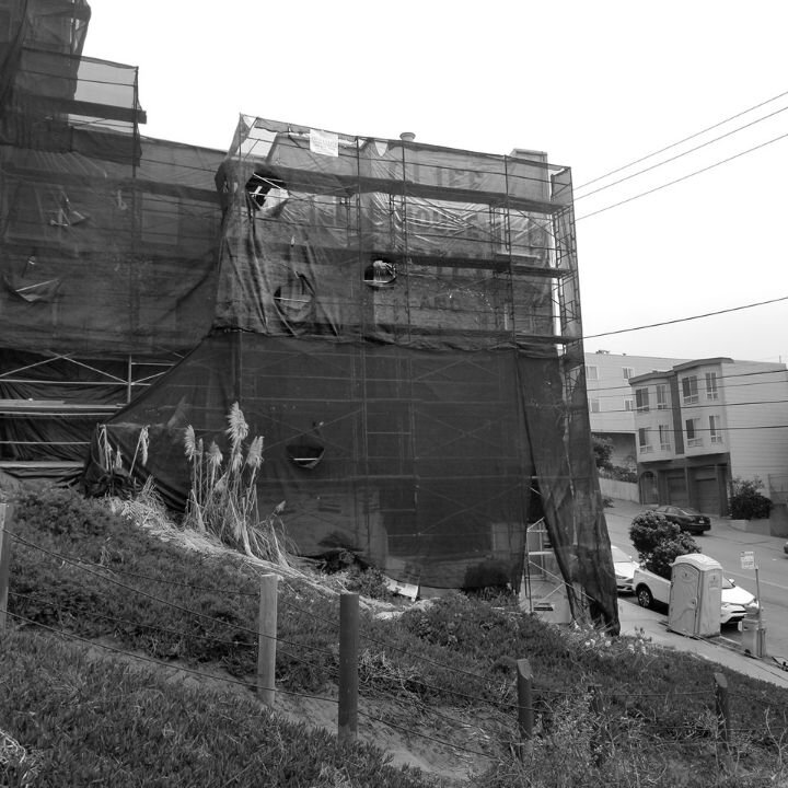
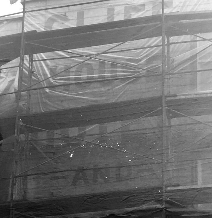
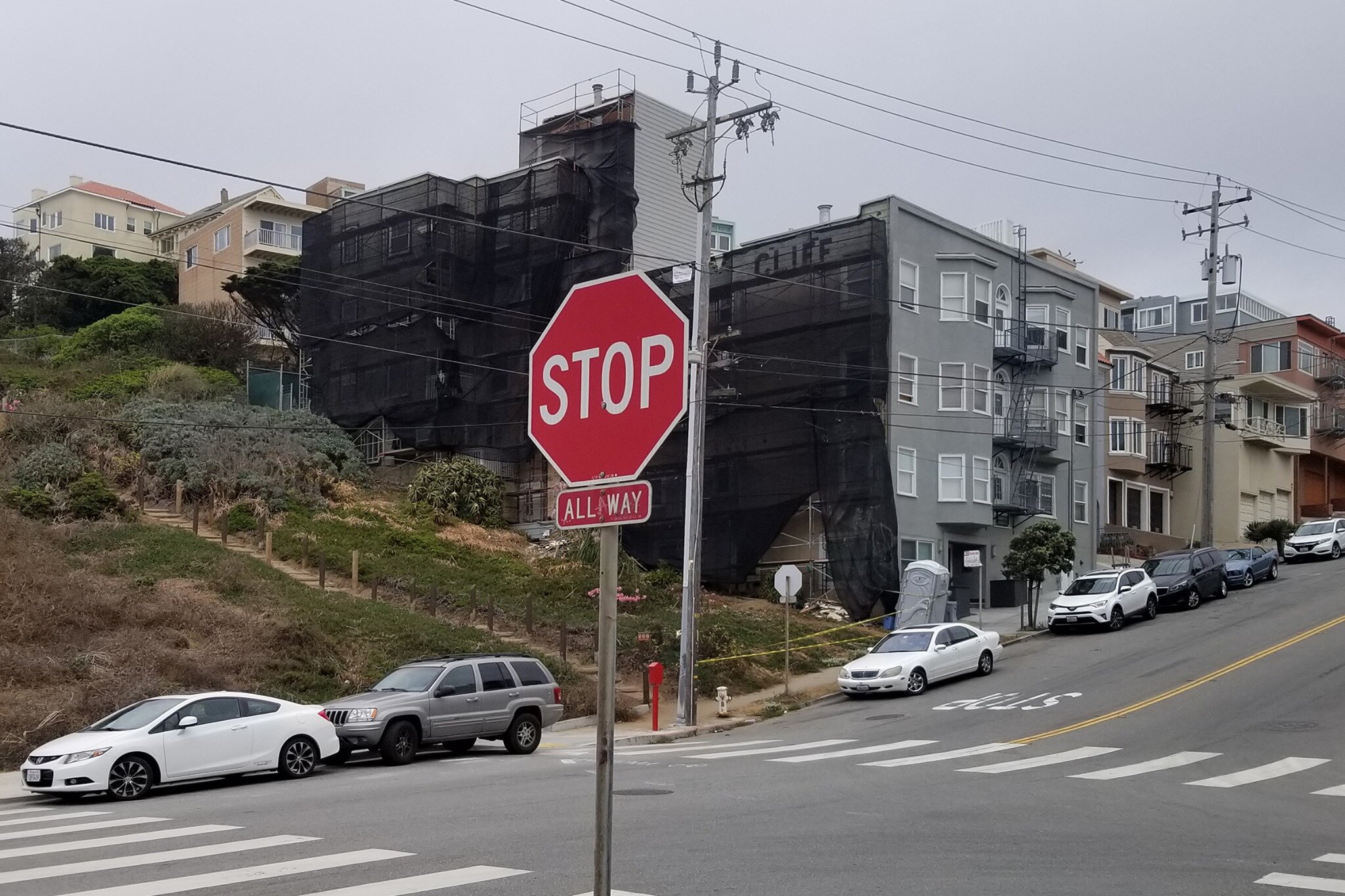
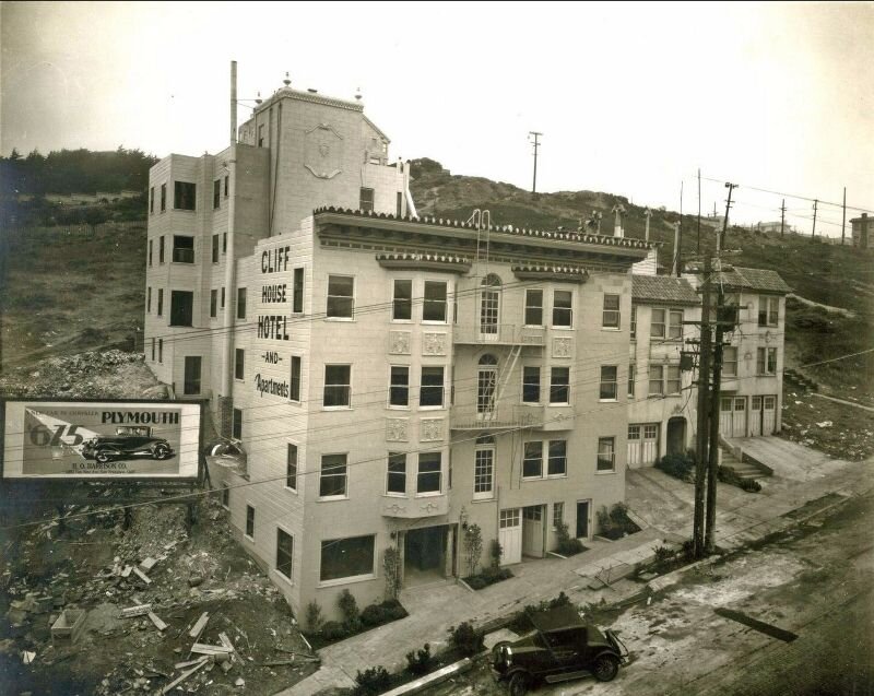
Thanks to the watchful eye of Chuck Revell from RevellRay Photography a new sign has been spotted near Ocean Beach on the corner of Balboa Street and La Playa Street.
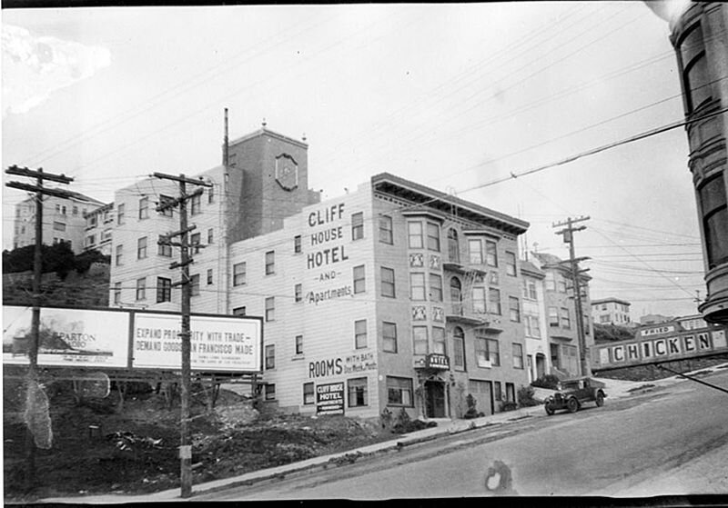
Uncovered during work on the building's siding, the sign points to a previous life as the Cliff House Hotel and Apartments. Below are shots of the building from the 1920's and 1930's. Look at how open and undeveloped the neighborhood looks!
Seen a recently revealed sign?
New signs are often revealed during renovation and demolition of older buildings in San Francisco. If you happen to see a newly revealed sign let us know at katherineclere@gmail.com!
Meacham Place and Owl Cigars /

Unlocked!
Finally someone left the gate unlocked! That’s a very intriguing Owl Cigar sign overlooking this alley. Wrapping around two sides of 921 Post Street, I’ve had trouble pinpointing where this sign was originally meant to be viewed from. The back side of the sign isn’t visible from Post, isn’t visible from Geary, and is only vaguely visible from Hyde. So where was it meant to be viewed from?
Peekabo, I sorta see you. As shot from Hyde
Originally I thought it was viewable from Meacham Place – a short public street blocked by a private gate. The internet seems to disagree as to why the street is locked. Some claim it was done illegally by the resident(s), some claim it was done legally by the resident(s), and some claim it was done by the city to protect the PG&E substation. Regardless, the gate is usually locked; except for yesterday when it wasn’t. Despite a last minute case of the nerves/indecisiveness I walked through the open gate, to the end of Meacham Place, and tried to photograph the Owl Cigar sign. No dice. Only the very edge of the sign is visible. This was obviously not the intended vantage point. Which leaves us with two possiblities: The intended view has been blocked by new construction or the sign was designed to be viewed from adjacent multi-story apartment buildings.

The Owl Cigar sign as seen from Meacham Place
So what if the sign was boxed in by new construction? Does this neat and tidy little theory stand up to research and testing? See the map below in which I’ve highlighted the sign on 921 Post street in red and included construction dates for all adjacent structures.

Construction dates of adjacent structures
921 Post, our building in question, was built in 1919/1920. According to real estate records, the buildings on Hyde predate 921 Post by three to fourteen years. Hence Hyde, at least from the street level, was not the intended vantage point as there’s been no “new construction” to block the sign. Now, the adjacent buildings along Geary were constructed three to five years after 921 Post but I’m fairly certain Geary wasn’t the intended vantage point either. Why? As shown in the photos below, this portion of Nob Hill starts getting steep and Geary sits considerably beneath Post. Even in front of 822 Geary, the sole single-story building in the area, one cannot see the roof of the mid-block PG&E substation let alone the buildings behind it. While the sign may have been partially visible from Geary pre-construction, it would have been significantly, perhaps entirely, blocked by this substation (built in 1900) and the angle of the hill. Hence I doubt that Geary was the intended vantage point either.
The view from 822 Geary

Hyde Street between Geary and Post
Which only leaves us one option – this Owl Cigar sign was meant to be viewed from adjacent multi-story apartment buildings. Now, this theory is a little harder to prove/disprove; most San Francisco residents aren’t going to let some strange photographer/blogger into their apartment to check out the view. So while I might not be able to prove anything I can still use maps and knowledge about the block to support my theory.

Buildings with potential/partial lines-of-sight
See the map above. As before, I’ve highlighted the Owl Cigar sign on 921 Post in red. The buildings highlighted in green have the distinction of being A) downhill from 921 Post B) being taller than 921 Post and C) being taller than the midblock or intervening buildings . Now, not every unit or every floor of these buildings has an unobstructed view of the sign – but perhaps enough do to warrant it’s existence? Especially since it’s connected to a larger sign with broad, and valuable, street visibility? Given what we’ve proved about visibility from other streets/angles this is the only theory I can really get behind.
TL:DR The Owl Cigar sign on the back of 921 Post was not designed to be viewed from Post, Meacham, Hyde, or Geary – it was designed to be viewed from the adjacent multi-story apartment buildings.
Ghost Signs of Google Satellite View /
I’ve used Google Maps extensively during the course of the my Ghost Sign Mapping Project – both as a mapping platform and a research tool. For while I try to keep a written record of where I’ve photographed each sign, sometimes I lose the notebooks or slips of paper or just plain forget to record the information. To fill in these documentation gaps, I’ve turned to a combination of Google Street View and Google Satellite View to Iink signs to buildings to addresses. I’ve chased many, many signs down this mapping rabbit hole and it’s become an invaluable tool in my War Against Disorganized Research (otherwise known as Leave No Sign Behind).
One day, while trying to pinpoint the location of a photograph I’d taken in the Tenderloin, I discovered that one could rotate the viewpoint and observe buildings/blocks/neighborhoods from multiple angles. While fiddling with this feature on Turk Street, I came across this set of signs (as well as an AMAZING rooftop airstream trailer) on 124 Turk Street.

Containing between three and four signs – including an Owl Cigars sign – only the front-facing sign of the sequence is visible from the street. So I started looking at more blocks and then more blocks and then more blocks until I’d collected approximately a dozen signs that are invisible from the street. Viola! Behold the fruits of my satellite enabled research!
How did these signs come to be hidden from public view? Accessible only to immediately adjacent neighbors and those with computer access?
Well, I’d wager that some of these signs were never meant to be viewed from the street. Between the hilly terrain and plethora of tall buildings in the Tenderloin, a sign could be targeted at the view of an adjacent high-value hotel or apartment with little concern for street traffic. Think of it as a proto-targeted ad campaign.
Also, I’d additionally wager that some of these hidden signs are the end result of post-1906 earthquake construction. Leveled by quake and fire, the Tenderloin was reconstructed in fits and starts from 1906 to 1912ish (and in some cases much, much later). Hence a sign that was visible to street traffic in 1907 might have been obscured by new construction as early as 1908 or 1909.
For example: 572 O’ Farrell Street – which contains a MJB Coffee sign on it’s Geary-facing side – was constructed immediately post-quake in 1907. While I’m not sure of the sign’s vintage, I do know the sight lines to Geary weren’t blocked until the construction of 669 Geary in 1922. That means it’s possible the sign enjoyed 15 years worth of high impact visibility – that’s more than enough time to pay off the salaries of the walldogs who painted it.

Have I missed any secret ghost signs only visible through Google Satellite view? Can you get me an up close and personal pic of any of the signs listed on this map? If so, please let me know!